
Dog Walks Around Andover – Step-by-Step Countryside Routes
Easy-to-follow dog walk guides around Andover, Ludgershall, Wherwell and the Test Valley, with start postcodes, distances and clear step-by-step directions.
MutTrails Walk Guide Library
A growing collection of countryside dog walks we regularly explore with dogs around Andover and the Test Valley. Each route includes the start postcode, distance and clear step-by-step directions so you can easily follow the walk with your dog. If you’d rather your dog enjoy these countryside routes with company, see our MutTrails Walk Service in Andover
Available MutTrails Walk Guides
| No. | Walk | Area | Miles | Start | Status |
|---|---|---|---|---|---|
| 1 | Ludgershall Wood Dog Walk | Ludgershall | 3 | SP11 7QR | Ready |
| 2 | Furzy Croft Woodland Dog Walk | Andover | 2 | SP10 2BZ | Ready |
| 3 | Hungerford Lane Countryside Dog Walk | Andover | 3 | SP10 4EF | Ready |
| 4 | Wood House Countryside Dog Walk | Enham | 2 | SP11 6HR | Ready |
| 5 | Parnholt Wood Dog Walk | King Somborne | 4 | SO20 6QH | Ready |
| 6 | Ladies Walk Woodland Dog Walk | Andover | 2 | SP10 2DJ | Ready |
| 7 | Solar Farm Countryside Dog Walk | Andover | 4 | SP11 6LZ | Ready |
| 8 | Test Valley Riverside Dog Walk | Stockbridge | 6 | SO20 6HA | Ready |
| 9 | River Dever Riverside Dog Walk | Barton Stacy | 4 | SP21 3RH | Coming Soon |
| 10 | Cow Common Countryside Dog Walk | Wherwell | 3 | SP11 7JT | Coming Soon |
| 11 | Water Works Dog Walk | Andover | 3 | SP11 7SF | Coming Soon |
| 12 | Enham Chase Woodland Dog Walk | Enham | 2 | SP11 6HG | Coming Soon |
| 13 | River Dever Alternative Dog Walk | Barton Stacy | 4 | SP21 3RH | Coming Soon |
| 14 | Railway Path Dog Walk | Wherwell | 2 | SP11 7JN | Coming Soon |
Ludgershall Wood Dog Walk – Ludgershall
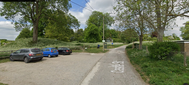
| Start / Finish | Ludgershall Castle Car Park SP11 9QR |
|---|---|
| Time / Distance | 1.5 hours / 3 miles |
| Terrain | Woodland tracks and field edges |
| Water Stop | Car park bowl refill area |
Summary: A gentle 3-mile circular countryside walk (approx 1.5 hours). Discover the peace and beauty of Ludgershall Woods — a quiet, tree-lined loop perfect for a relaxed Sunday adventure. This trail combines gentle countryside paths with shaded woodland tracks, giving both dogs and owners a refreshing escape from the week.
Route Directions:
- 1) Park in Castle Car Park. Look for gate left of information board and follow grass track.
- 2) At fork take upper left-hand track to gate onto track.
- 3) Ignore gate ahead to castle; turn left down to gap in hedgerow to open field.
- 4) Through gap turn immediately right along field edge toward woods.
- 5) At bottom right corner go through gap in fence and turn right onto grass track.
- 6) Follow track until it splits; turn left towards houses.
- 7) At fork by sign turn left into woods by barrier.
- 8) Keep straight on this track ignoring turns until end of track.
- 9) Walk through gap to open field, turn left keeping field edge around woods.
- 10) Follow round to metal and wood gates; pass through and turn right following track to barn.
- 11) Ignore left track and pass barn ahead to end of field.
- 12) Go through gate and turn sharp right onto narrow track into trees.
- 13) Keep straight until opening with three directions.
- 14) Ignore right and straight-ahead tracks; turn right onto track heading down.
- 15) Keep straight until houses on left.
- 16) Pass these and head down to bottom corner path.
- 17) Head straight up through gap walking up field edge back to castle car park.
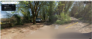
Furzy Croft Woodland Dog Walk – Andover
| Start / Finish | Old Winton Rd, SP10 2BZ |
|---|---|
| Time / Distance | 1 hour / 2 miles |
| Terrain | Dirt track |
| Water Stop | None |
Summary: A straightforward 2-mile dirt-track route starting from Old Winton Road. This walk has a mix of wide tracks, wooded sections and a few forks to navigate, making it a pleasant short trail for confident walkers and dogs who enjoy a bit of variety.
Route Directions:
- 1) At the bend of Old Winton Rd with South End Rd, take the small road on the bend and park under the trees on the left. Walk back to the road and turn left, going straight up the dirt track under the height-restriction barrier.
- 2) Ignore the higher track on the right and continue straight on going under underpass.
- 3) Follow the track until reaching road.
- 4) Walk straight across the road to continue along the track on the other side.
- 5) Pass the left-hand turn by the marker and keep straight with the golf course on your right until the next fork.
- 6) At the fork turn sharply left onto a narrow path through the woods.
- 7) As the track clears the wood and opens into a field edge, stay on the path which leads you back into the woods.
- 8) At a very narrow crossroads near the edge of the woods, take the sharp right-hand path leading back into the woods (not the straight-ahead or left-hand paths).
- 9) Follow this winding woodland path. At the fork, keep left.
- 10) Look for a gap on the right.
- 11) Go through the gap, ignoring the first turning on the right. Continue a few paces to the next fork.
- 12) At this fork turn right onto the main track and continue straight, crossing back over the road to return to the start.
Hungerford Lane Countryside Dog Walk – Andover

| Start / Finish | Icknield Way, SP10 4EF |
|---|---|
| Time / Distance | 1.5 hour / 3 miles |
| Terrain | Dirt track |
| Water Stop | Hare & Hounds Pub |
Summary: A 3-mile circular countryside walk from Icknield Way, following Hungerford Lane through farmland and woodland, with an optional refreshment stop at the Hare & Hounds.
- 1) Park as close as you can to Icknield Way. Walk to Hungerford Lane opposite and join the track, heading uphill as shown by the white arrow on the map.
- 2) Continue on the track until you reach a farm building in an open square area.
- 3) At the farm building, take the track on the right into the trees.
- 4) Keep ahead, ignoring any side tracks or stiles on the left or right.
- 5) At the next major left-hand track at the bottom of a dip, beside a footpath marker, turn left.
- 6) Follow this track until you reach a small gap on the left with a footpath sign leading into the fields. Go through the gap.
- 7) Walk diagonally across the field to the top right-hand corner.
- 8) At the corner, keep right and walk a short distance to a crossroads of tracks.
- 9) At the crossroads, take the right-hand track, heading downhill towards another crossroads.
- 10) At this next crossroads, go straight across and continue on the main track, walking uphill to a fork.
- 11) At the fork, ignore the track on the left and take the right-hand track, with the field you crossed earlier on your right.
- 12) Continue straight to a T-junction. Turn left for the Hare & Hounds pub, or turn right and follow the track back down to your starting point.
Wood House Countryside Dog Walk – Enham
| Start / Finish | Knightbridge Rd, SP11 6HR |
|---|---|
| Time / Distance | 1 hour / 2 miles |
| Terrain | Country lanes |
| Water Stop | Enham Café (main road) |
Summary: A relaxed countryside loop starting from Knightbridge Road, taking in fields, quiet lanes and village edges, with an optional café stop at Enham.
- 1) Park on Knightbridge Rd. Turn back to the end of the main road and keep walking towards the houses on a private track on your right, heading into a field (as shown by the arrow on the map).
- 2) Go through the gate and head straight across the field towards a turn-stile gate, passing a cottage on your right.
- 3) Once through the gate, turn left onto the track and follow it down between fields to the end of the track.
- 4) Go through and veer slightly left, continuing straight on.
- 5) This brings you out onto a lane between village houses. Follow the lane down to the main road.
- 6) At the fork, turn left, passing Woodhouse Farm on your left.
- 7) Continue along the road, passing Malt Hose Lane on your left.
- 8) Follow the road as it bears left heading towards Hurstbourne Tarrant, going uphill.
- 9) At the top, ignore the footpath sign and stile on the left. Stay on this road until reaching Dunhills Lane. Turn left and follow until reaching Malt House Lane on your left.
- 10) Turn left and follow the lane back to the main road.
- 11) At the main road, turn right, then right again to return to the lane mentioned earlier.
- 12) At the top of the lane by the stile, go through and follow the narrow track back to the gate near the bottom, returning to the field at the start of the walk.
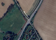
Parnholt Wood Dog Walk – King Somborne
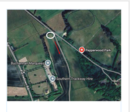
| Start / Finish | Slip road to Pepper Wood, SO20 6QH |
|---|---|
| Time / Distance | 2 hours / 4 miles |
| Terrain | Lane & forest tracks |
| Water Stop | None |
Summary: A longer countryside and woodland walk through Parnholt Woods, using forest tracks, bridleways and open fields before looping back via Pepper Wood Park. Best suited to dogs comfortable with longer distances.
- 1) Park on the side of the lane opposite the fork leading up to Pepper Wood, with a footpath on the right (shown by the white circle and red arrow on the map).
- 2) Take the right-hand turning onto the footpath, walking between fields up to the Pump House.
- 3) Keep on this track, passing the Pump House on your right.
- 4) Ignore the Parnholt sign and gate on your right and keep on the same track.
- 5) On reaching a fork, keep straight on, following the track towards the trees.
- 6) At the next fork, by a notice board on the left, keep following the track straight on.
- 7) At the crossroads, turn left and continue following the main track.
- 8) At the next crossroads, by a green gate on your right, keep walking straight on.
- 9) At the Clarendon Way sign, turn left onto a dirt track heading back into the woods. This track becomes a narrow path and leads out of the woods down a steep decline, with fields on your right.
- 10) On reaching the bottom by two metal gates, keep straight on, walking through the middle of the field towards a lane.
- 11) Turn left by another Clarendon Way sign on the corner just before the lane, onto a track running between two fields.
- 12) Head up, keeping on the same track as it bends around a corner towards the woods.
- 13) At the crossroads, by a bridleway sign on the right, keep straight on.
- 14) After a few hundred paces, look out for a fork with a marker on the right. Ignore this and continue straight on.
- 15) Keep following this track all the way down to Pepper Wood.
- 16) Continue straight down along the tarmac road, leading back down to where you started.
Ladies Walk Woodland Dog Walk – Andover
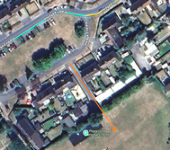
| Start / Finish | Hedge End Road, Andover SP10 2DJ |
|---|---|
| Time / Distance | 1 hour / 2 miles |
| Terrain | Lane and open fields |
| Water Stop | None |
Summary: A short, easy 2-mile circular walk taking in open fields and well-used paths. Ideal for a quick local leg-stretch or calmer dogs who enjoy space without heavy footfall. Mostly flat with a mix of field edges, tracks, and an underpass.
Route Directions:
- 1) Park on Hedge End Road. Walk through the gap between houses into the field.
- 2) Walk diagonally across the field toward the top right-hand corner. Go through the gap and turn left up the steps.
- 3) At the top turn left, ignore the gap on the right, and continue straight on.
- 4) After passing back of the BW Hotel on the left, approach an iron bridge. Just before it, use the small gap in the hedgerow on the right.
- 5) Go through the gap, keep left across the field to the next corner, then turn right keeping the hedgerow on your left. Walk through the next gap.
- 6) Turn immediately left and follow the field edge downhill to the crossroads.
- 7) At the crossroads, go straight across heading down to the underpass on the second track on the left.
- 8) Go through the underpass bearing left toward a metal gate at the top.
- 9) Pass around the gate and keep straight, following the edge of the solar field on your right toward the farm buildings.
- 10) At the buildings, go through the metal gate onto the tarmac road.
- 11) Turn right and follow the road, passing Cow Down Nursery on your left.
- 12) Head up the hill, ignore the gap on the left, then turn right onto open fields following the field edge downhill.
- 13) At the crossroads by the copse and solar field, turn right and follow the track back toward the metal gate by the road.
- 14) At this corner, turn left and walk back down toward the metal gate near the underpass.
- 15) Go through the underpass back into the fields. Walk straight up, ignoring the right-hand tracks.
- 16) Continue straight to the corner of the field and turn left.
- 17) Go through the gap back onto the Ladies Walk path. Cross over to the steps leading down to the play area and return to the start.
Solar Farm Countryside Dog Walk – Andover
| Start / Finish | Ashley Court Hotel, SP11 6LA |
|---|---|
| Time / Distance | 1.5 hours / 3 miles |
| Terrain | Road, track, field |
| Water Stop | None |

- 1) Park at the layby on the left on Micheldever Rd, just past the turning for Ashley Court Hotel.
- 2) Head up the road towards the iron bridge, pass under and keep on the road.
- 3) Ignore the left turning to the private road, then the second left onto the tarmac path. Go by the metal barrier, walk around it, and head to the small gap in the corner of the field on your right.
- 4) Go through into the fields via the small gap.
- 5) Walk through the middle of the fields and keep straight on the track.
- 6) As it narrows and turns into a corner, take a sharp left to follow the track down to the A303 underpass.
- 7) Go under and follow up to the metal gate. At the gate, keep left to follow the track with the solar field on your right.
- 8) Walk around the bend and up to the top corner by another gate opposite the industrial units.
- 9) Ignore the gate onto the road and keep following the track around the corner and straight on, with the solar field now on your right.
- 10) At the top of the hill (near beehives and a copse on the right), at the crossroads turn left to walk along the field edge towards Cow Down Lane.
- 11) At the road turn right and walk down until you reach a bridleway crossing. Turn right here onto the bridleway.
- 12) Follow this track all the way to the underpass. Go through and continue walking straight ahead.
- 13) At the end of the track take a sharp right onto Ladies Walk.
- 14) At the fork by the gate, leave the path and take the right lane heading up to the farm.
- 15) Turn right through the gap onto a field, keeping to the left-hand edge. Follow it around, passing the farm yard on your left.
- 16) At the end of the track go through into the next field, walking straight across the middle to the next field.
- 17) At the corner, turn first right to follow the field down, keeping the hedgerow on your left.
- 18) Take the next left through the gap and walk straight on to the next corner.
- 19) At the next corner turn left and walk down the left-hand edge to the small gap in the corner at the bottom.
- 20) Go through the gap back onto Ladies Walk by the iron bridge.
- 21) Keeping the bridge on your right, walk straight ahead through the gate to the path leading down, passing Hotel on your left.
- 22) Half way along, there’s a gap on your right that takes you back to where you parked your car.
Test Valley Riverside Walk – Andover
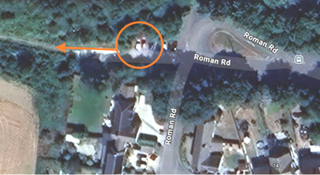
| Start / Finish | Roman Road, SO20 6HA |
|---|---|
| Time / Distance | Around 3 hours / 6 miles |
| Terrain | Road, fields, dirt tracks |
| Water Stop | Stockbridge High Street, stream |
Summary: A longer countryside circular walk with open tracks, field edges, quiet village roads, a stream stop, and a stretch through Stockbridge before heading back up to Roman Road. Best for dogs happy with a longer mixed terrain route.
Route Directions:
- 1) Go to the end of Roman Road and park at the top next to the track.(as shown by red markings)
- 2) Head up the track away from the car bay, keeping straight until you reach a concealed stile on the right by a TW marker, just by the chicken coop on the left.
- 3) Go through the gap into a small orchard and follow the path to the road and stile.
- 4) Cross over the road and go through the gap opposite, following the track along the right field edge.
- 5) Keep to this track for about 1 mile until you reach a metal gate and stile.
- 6) Cross the stile and turn right onto the track between hedgerows, following it for about half a mile to the road.
- 7) Carefully cross over the road heading diagonally right by the road marker and give way sign. At the turning area, look for a track straight on with a height restriction bar.
- 8) Walk under the bar and follow the track for about 1 mile to a tarmac lane leading to the village.
- 9) At the T-junction by the church, turn left then first right onto The Bunny by the Peat Spade Inn.
- 10) About 50 yards down on the left there is a stream.
- 11) Keep straight on this quiet road, crossing over 3 small bridges.
- 12) Nearing the end of the road at the give way sign just before the railway bridge, look out for the TW sign.
- 13) At the TW sign turn right onto the track leading down onto the disused railway track.
- 14) Turn right at the bottom and follow the track to the second TW sign, ending by the main road.
- 15) At the road turn right, keeping to the pavement down to the roundabout, then keep right into Stockbridge.
- 16) Turn right onto Stockbridge High Street and carry straight through, passing all the shops.
- 17) Cross over the bridge at the other end of the street, passing Haydown Kitchen, then head straight back up the hill to the school and Roman Road again.
River Dever Riverside Dog Walk – Barton Stacy

Coming soon.
Cow Common Countryside Dog Walk – Wherwell

Coming soon.
Water Works Dog Walk – Andover

Coming soon.
Enham Chase Woodland Dog Walk – Enham

Coming soon.
River Dever Alternative Dog Walk– Barton Stacey

Coming soon.
Railway Path Dog Walk – Wherwell

Coming soon.